Nor'easter Set to Drop Foot of Snow Over Berkshires| 06:42PM / Saturday, February 21, 2026 | |
Here we go again.
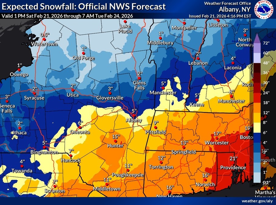
A powerful Nor'easter is set to drop up to a foot of snow over the region, right on the tail Friday's storm that dropped up to 6 inches in some areas.
The National Weather Service in Albany, N.Y., has issued a winter storm warning beginning at 1 p.m. on Sunday through 7 p.m. on Monday for the Berkshires, eastern New York, Southern Vermont and northern Connecticut.
Heavy snow expected with total accumulations between 8 and 14 inches with some locally higher totals possible over the high peaks of the Catskills. Winds could gust as high as 45 mph.
The storm center was lining up to hit New York City but has been shifting north. Southern Berkshire could see a few more inches that North County, unless the storm moves further north.
Vermont schoolchildren will be starting their winter vacation Monday but Berkshire kids will be headed back to school. But they might be getting an extra vacation day -- Greylock Snow Day has an 80 percent probability for of delays, a 75 percent chance for closures in South County.
With the storm sweeping in by Sunday afternoon, we'll be on the lookout for any cancellations. This post will also be updated if new information becomes available.
Pittsfield is implementing parking restrictions: park on the even side on Sunday through 7 a.m. Monday, then switch to the odd side through 7 a.m. Tuesday. Downtown residents are encouraged to use the McKay Street Parking Garage for overnight parking, free until Tuesday at 7 a.m.
All Berkshire residents are reminded that most municipalities have winter parking bans in effect — no overnight parking on roadways to allow for plows to get through. Violators may be towed or ticketed.
A ccuweather is describing blizzard conditions affecting coastal areas and the I-95 corridor with up to 18 inches of snow, with rates of 1 to 3 inches an hour. It's expected to be heavy, wet snow that could make shoveling difficult and dangerous.
Temperatures, however, aren't likely to dip back into frigid territory and Tuesday will see clearing and sunnier skies.
Twenty-nine days to spring.
This storm will track in the vicinity of the benchmark with a central pressure in the 970 millibar range. That's just what's needed for a widespread, high-impact snowstorm with blizzard conditions possible. There's currently a 60% chance for snow rates of 2-3" an hour. #MAwx #CTwx #RIwx #NHwx #MEwx
[image or embed]
— New England Storm Center (@nestormcenter.bsky.social) February 21, 2026 at 6:41 PM
National Weather Service Boston office post on Facebook a short time ago [Aside: I sure wish the Boston office would post here also in addition to @nws.noaa.gov .] #MaWX #Noreaster #Snow
[image or embed]
— Boston Metro Weather Forecast Bot (@boston-4castbot.bsky.social) February 21, 2026 at 5:43 PM
|