Berkshires' First Snowstorm Could Bring Nearly a Foot of Snow| 10:00PM / Monday, December 01, 2025 | |
NORTH ADAMS, Mass. — The first significant snowstorm of the season is expected on Tuesday, with heavy snowfall forecast across Western Massachusetts.
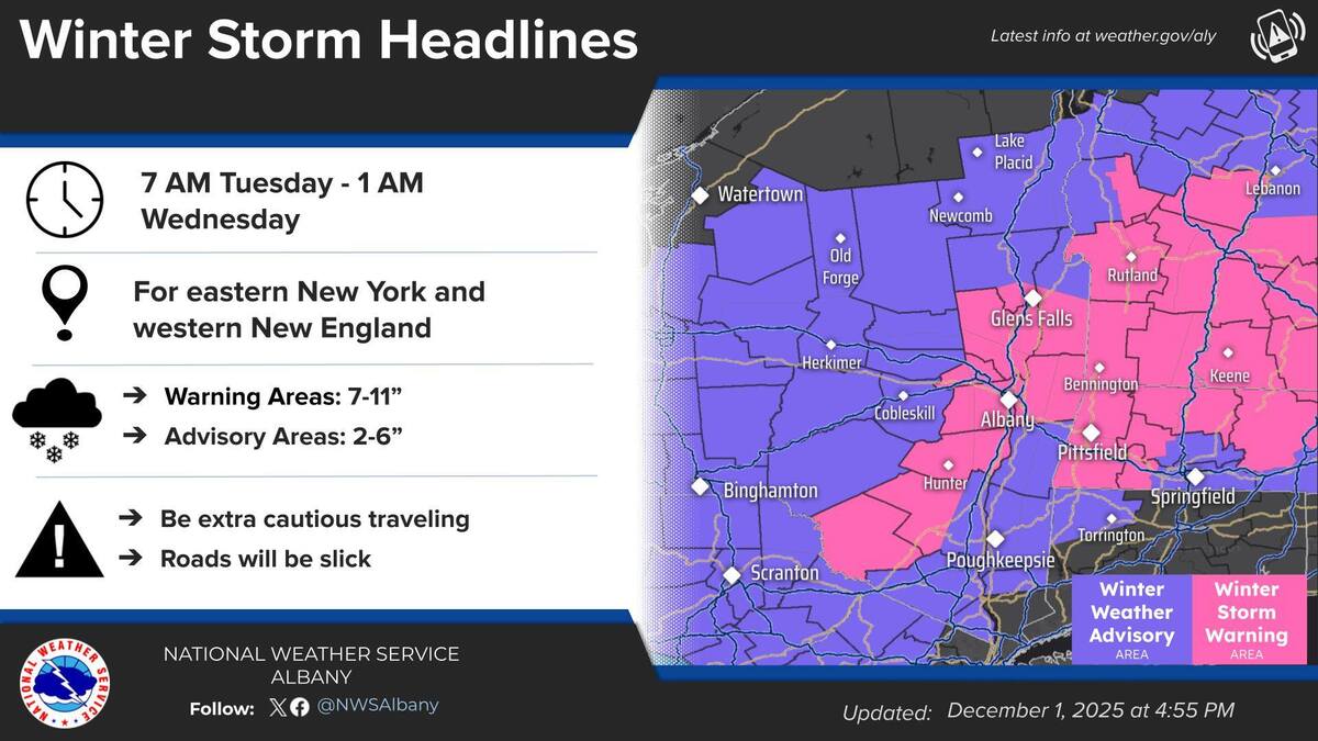
The National Weather Service in Albany, N.Y., has issued a winter storm warning starting at 7 a.m. on Tuesday with nearly a foot of snow forecast to fall through the day. The warning covers the Berkshires, Southern Vermont and parts of eastern New York State.
As of late Monday, the forecast was 7 to 11 inches of snow accumulation over the Berkshires and Southern Vermont. Snow will be begin falling between 5 and 7 a.m., moving east to west.
Greylock Snow Day has adjusted its snow-day meter to 75 percent, with a 50 percent chance of early release. By late Monday, Berkshire Arts & Technology Public Charter School, Northern Berkshire School Union schools and Readsboro, Vt., had canceled classes.
Berkshire Community College has also canceled classes as has Williams College, which is also closing its Children's Center.
MCLA will be closed today. Day and evening classes have been cancelled.
Closures:
>
Peter W. Foote Vietnam Veterans Memorial Rink
Mountain Dog Academy
Berkshire Food Project
The Boys & Girls Club of the Berkshires
Berkshire Emporium and Dino.Cafe
Reminder that most cities and towns have winter parking bans in place: Parking on the street overnight could result in your vehicle being towed.
Pittsfield has restricted parking to the even side of the street beginning at 7 a.m. Tuesday through 7 a.m. on Wednesday. Vehicles should shift to the odd side of the street beginning Wednesday at 7 a.m. through Thursday 7 a.m. to allow for snow cleanup.
The McKay Street parking garage is open for free overnight parking starting Tuesday, Dec. 2, at 7 a.m. through the duration of the emergency. Trash and recycling pickup for Tuesday, Dec. 2, is canceled and will resume with a one-day delay on Wednesday.
Hazardous travel is expected particularly during the afternoon because of snow-covered roads and poor visibility.
Moderate to heavy snow will impact the evening commute Tuesday. Snowfall rates between a half-inch and an inch are expected within the warned areas. Caution is advised for all motorists.
WTEN's Storm Tracker has most of the Berkshires and Southern Vermont seeing 5 to 8 inches; snowfall is expected to be ligher and mixed with rain to the south.
There's still a chance the storm could shift slightly, which will affect snow totals. AccuWeather says the speed of the storm could also decrease snow accumulations. The Accuweather team is also forecasting that December will stay "cold and stormy" for the next two weeks.
A thump of snow is incoming to a large portion of New England tomorrow. While not an overly intense storm, it will bring a widespread 4-8 inches and kick off meteorological winter with a bit of a bang. Details: #MAwx #CTwx #RIwx #NHwx #MEwx #VTwx www.newenglandstormcenter.com/post/thump-o...
[image or embed]
— New England Storm Center (@nestormcenter.bsky.social) December 1, 2025 at 7:46 AM
National Weather Service Boston office's snow forecast map:
[image or embed]
— Boston Metro Weather Forecast Bot (@boston-4castbot.bsky.social) December 1, 2025 at 8:01 AM
|