Snow, Sleet & High Winds for Presidents Day Weekend| 01:41PM / Saturday, February 15, 2025 | |
Another weekend, another storm for the Berkshires.
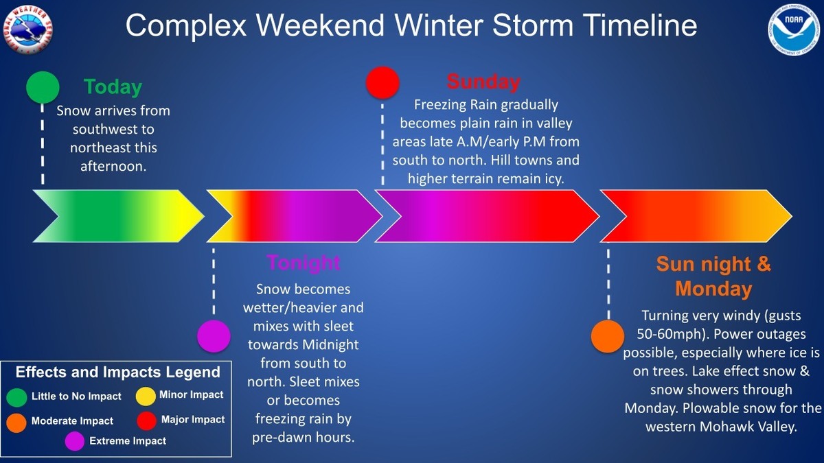
The National Weather Service in Albany, N.Y., is forecasting 3 to 7 inches of mixed precipitation beginning Saturday afternoon. Ice accumulations may be between one-tenth and three-tenths of an inch.
A winter weather advisory is in effect from 1 p.m. on Saturday to 7 p.m. on Sunday.
Snow will continue through this evening before transitioning to a wintry mix overnight into Sunday afternoon. Some areas may change over to plain rain before precipitation tapers off.
This expected to followed by high winds Sunday night with gusts reaching up to 60 mph. Strong winds combined with any ice on trees could result in additional power outages. A high wind watch is in effect from 7 p.m. Sunday through Monday evening.
Roads, and especially bridges and overpasses, will likely become slick and hazardous from snow, sleet and ice accumulations. Plan on slippery road conditions. Power outages and tree damage are possible due to the ice, snow and winds.
North Adams, Pittsfield and other communities have declared snow emergencies which means no parking on the street. In Pittsfield, parking is allowed only on the odd side of the street on Saturday beginning at 7 a.m. and the even side, also beginning at 7 a.m., on Monday. Downtown residents are being encouraged to the McKay Street parking garage free of charge during the emergency.
Travelers should allow for extra travel time and check forecasts for their routes and destinations and, if possible, consider using public transportation in place of a personal vehicle. MassDOT crews have been pretreating roadways in advance of the storm and will be deploying snow removal staff and equipment as necessary across the commonwealth. Download the?Mass511?mobile app or visit? www.mass511.com?to view live cameras, travel times, real-time traffic conditions.
National Grid is preparing for icing, snow, hazardous winds and cold temperatures. Wind gusts have the potential to damage trees and knock down power lines, causing power outages in impacted locations. Icing can lead to sagging powerlines and tree limbs. The timing of the changeover to snow and freezing rain will influence snow and ice amounts, with higher snow totals across Western Massachusetts.
Avoid dangerous downed powerlines; report power outages at www.nationalgridus.com or call 1-800-465-1212. Use your mobile device to track outage information and storm-related safety tips through National Grid's mobile site, accessible at www.ngrid.com/mobile.
"National Grid has been tracking this storm for several days and we have crews and personnel ready to respond to any impacts from the weather," said Shaun Vacher, vice president of electric operations, New England. "In the event of outages, our crews and support teams will be working for as long as needed to restore service as quickly and safely as conditions allow."
A look at alerts as we head into this messy storm. It's increasingly likely that it will turn very windy on the backside of the storm into Monday. With some icing and little melting, this could be an issue #MAwx #CTwx #RIwx #NHwx #MEwx #VTwx
[image or embed]
— New England Storm Center (@nestormcenter.bsky.social) February 15, 2025 at 11:47 AM
February 14-15th, 1940: A Valentine's Day blizzard hit the northeastern United States with 10 to 18 inches of snow over southern New England. It took 17,000 men on the 15th to shovel out Boston. www.newenglandhistoricalsociety.com/valentines-d...
[image or embed]
— Weather History (@weatherhistory.bsky.social) February 15, 2025 at 9:28 AM
|