All That Snow Expected to Fall Southward| 12:22PM / Monday, February 12, 2024 | |
 |
NEVERMIND: The National Weather Service has canceled its Winter Storm Warning and has a Winter Weather Advisory only in place for the Berkshires from 1 a.m. Monday to 7 p.m. Tuesday.
Total snow expected: 2 to 4 inches. South County could get up to 6.
This fast-moving storm is heading south and east and may miss us completely.
_____________________________________________________________________
Parts of the Berkshires could get nearly a foot of snow early this week as a Nor'easter barrels through New England.
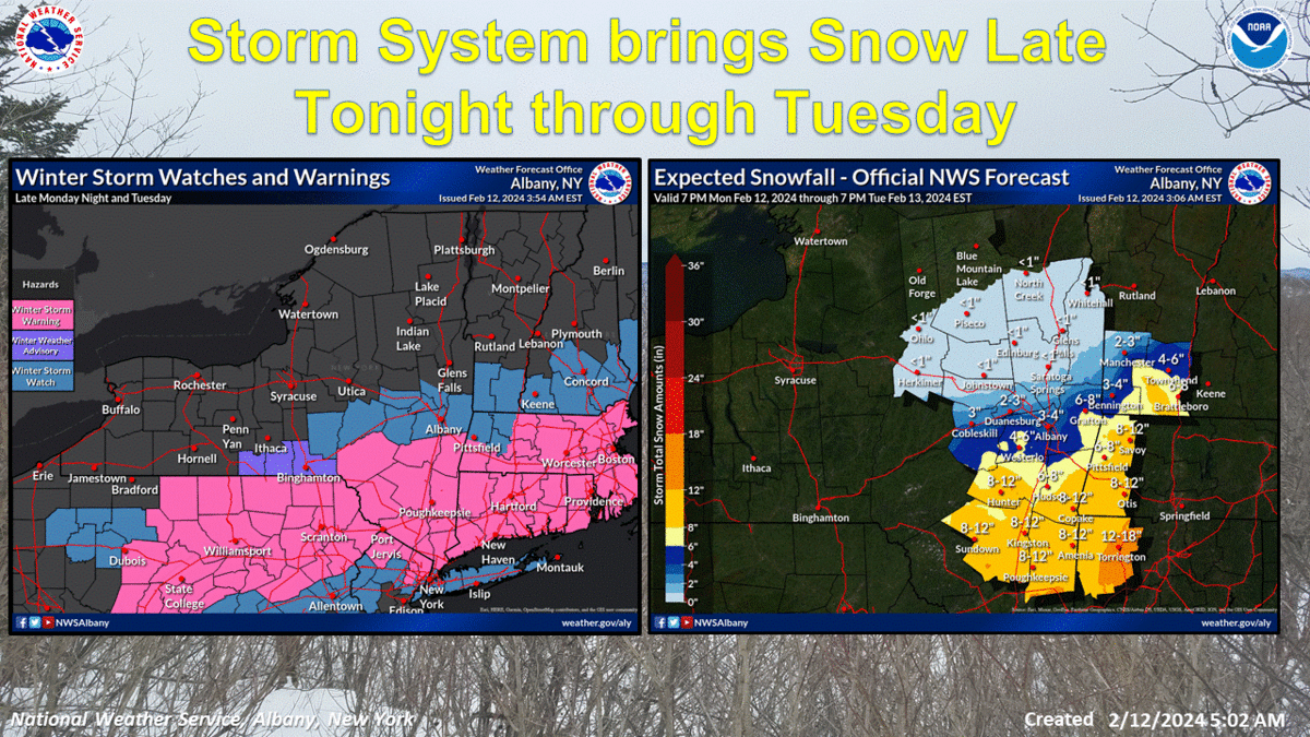
The bulk of the storm system is now expected to pass below North Berkshire. NWS says there will be a sharp cutoff between low and high snowfall accumulations but uncertainty in how far north and west the axis of heaviest show will extend.
The snow line cutoff looks to go through Pittsfield with North Berkshire getting anywhere from 2 to 6 inches.
The rest of the state might not be so lucky. Gov. Maura Healey has notified nonessential executive office employees to stay home and Boston and Springfield have already closed schools.
"This is a #noreaster with #bombogenesis - expect the worst" tweeted NBC Boston's Pete Bouchard on Sunday morning.
The dire warnings of heavy snow for Northern Berkshires over the weekend shifted drastically south by Monday morning.
The National Weather Service in Albany, N.Y., on Sunday evening added a Winter Storm Warning for Southern Berkshire beginning a 1 a.m. Monday through Tuesday.
A Winter Storm Watch was issued earlier on Sunday for North Berkshire remains in effect from late Monday night through Tuesday evening. This covers New York's Capital District, all of Southern Vermont as well.
The forecast so far is for heavy wet snow overnight Monday that could seriously hamper the morning community. Snowfall rates could exceed one inch an hour overnight. It's possible the higher elevations could see more snow.
Accuweather's "StormMax" is 17 inches in the higher elevations.
CBS WBZ-TV in Boston is warning of blizzard conditions, particularly during Tuesday morning and afternoon. The track of the storm as it moves north up the coast will determine how much snow and where it will impact most. WBZ-TV on Sunday said Boston has not had more than 4 inches of snow in 715 days.
Greylock Snow Day's Confidence Meter is at 75 percent chance of a snow day for South County on Tuesday based on current timing of the storm and an estimated snowfall of 5 to 10 inches. Chances for a snow day in North County has been reduced to 15 percent and 50 percent in Central Berkshires.
iBerkshires will update this article as new information and cancellations are announced. Residents should assume snow emergencies will be declared by Monday are reminded not to park overnight on the streets to facilitate snowplowing.
Pittsfield declared a snow emergency early Monday but cancelled it Tuesday morning.
|