Nor'easter Could Drop Up to 2 Feet of Snow Across the Berkshires| 05:43PM / Monday, March 13, 2023 | |
Winter's come late to the Berkshires. A third significant storm in as many weeks is forecast to drop a foot or more of snow overnight Monday and through Tuesday.
This Nor'easter arrives barely a week before the first day of spring and some local meteorologists are already comparing to the "Storm of the Century" of 1993 that occurred 30 years ago on March 12-14.
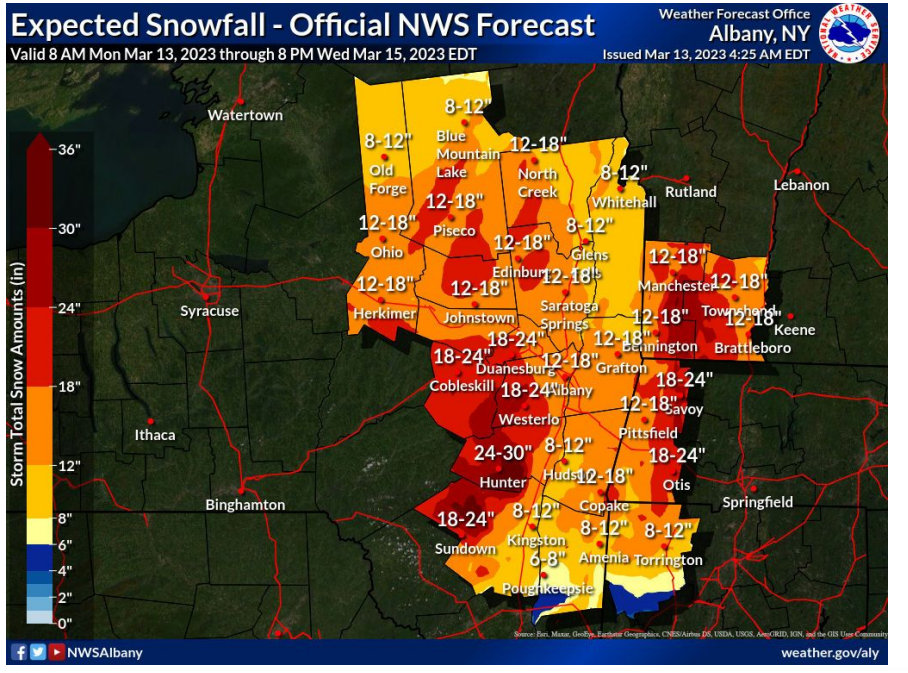
The National Weather Service in Albany, N.Y., has issued a winter storm warning beginning at 8 p.m. on Monday through Wednesday 8 a.m. Snow accumulations of 12 to 18 inches can be expected across the Berkshires, Southern Vermont and Western Mass., and 20 inches or more in the higher elevations.
Travel may be "difficult or impossible," according to NWS, and heavy wet snow may cause downed tree limbs and wires.
Snowfall rates will be reach 1 to 2 inches an hour at times accompanied by strong winds especially later on Tuesday. This could reach blizzard conditions of 35 to 40 mph winds and reduced visibility.
Accuweather reports two systems — one moving east across the Midwest and a larger storm moving up the coast — will combine as they move into the Northeast with the potential forming a bomb cyclone.
Accuweather says snowfall rates could be 2 to 3 inches an hour in some areas from New York State to Maine and that high points in the Berkshires and Green Mountains could get an astonishing 36 inches!
Our friends at Greylock Snow Day say they aren't mincing words on this prediction: "students from pre-school to college are not going to be in session on Tuesday."
iBerkshires will be reporting any closures as soon as we get them (probably Monday evening after the 6 p.m. weather report) and any other cancelations.
Assume that snow emergencies will be in force throughout the county by early Monday evening. That means no parking on streets to allow for plows to get through.
• Pittsfield on-street parking is limited to the odd side of the street from Monday night through 7 p.m. Tuesday when it switches over to the even side. The McKay Parking Garage is open for overnight parking.
• North Adams: All public buildings closed for Tuesday, City Council meeting is canceled and the snow emergency starts at 5 p.m. on Monday.
• BCC and MCLA have both closed for Tuesday.
• Otis public buildings are closed and the Select Board meeting canceled.
"National Grid has been monitoring the forecasts closely for multiple days. We have secured additional crews and personnel across Massachusetts who are ready to respond as quickly and safely as possible to any impact this storm may bring," said Tanya Moniz-Witten, vice president for electric operations for New England.
National Grid is preparing for this storm by securing more than 1,000 field-based crews and more than 3,000 personnel as part of the company's emergency response operations. This includes overhead line, forestry, contractors, underground, damage assessment, wires down, transmission, and substation workers.
|