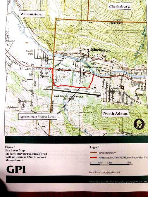
The red line shows the path crossing over a wetlands to the airport, paralleling the runway and exiting through Airport Road to Route 2.
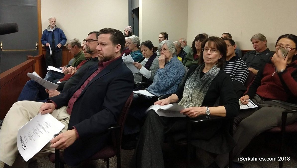
NORTH ADAMS, Mass. — Opponents and proponents of the planned Mohawk Bike Path in the West End held forth on Wednesday at a standing-room-only hearing at City Hall.
Many of the arguments at the state Department of Transportation public hearing were repeats from past hearings during which abutters on Chenaille Terrace had asserted the bike path on city land would be detrimental to their neighborhood.
Project manager David Shedd, Greenman-Pedersen Inc. transportation engineer Matthew Kearney, and other MassDOT representatives explained the project and took public comment.
"The plans are not complete, and we still have some design to go ... and the purpose of the hearing is to solicit your input regarding the project," Shedd said. "The plans are not yet complete, and we may not be able to answer all of your questions or respond to all of your concerns at this time."
Kearney gave an updated outline of the project and said this 1-mile segment of the proposed trail would begin in Williamstown at the former Spruces and follow Route 2 to Galvin Road, where it would cross the roadway and continue to Harriman-West Airport and eventually follow Airport Road back to Route 2.
Of this, 0.8 miles will be paved, 0.2 will be sidewalk and shared lanes, and 0.07 will be the boardwalk over the Paull Brook to the airport grounds.
Where the path joins Route 2, there will be a 6-foot grass buffer between the path and traffic and where the path crosses the road there will be a HAWK, or High-Intensity Activated crossWalK, beacon.
Kearney said the light will only be activated when a path user hits the button. This will trigger a flashing yellow light that eventually turns solid yellow, then red. The light will blink red once the path user is finishing his or her crossing.
There will be two overlook areas, one at the former Spruces and one at the airport. He said these areas should draw people and keep them from stopping on the trail in residential areas.
"We want to make sure the places where people slow down and stop aren't right behind houses, so we are looking at an overlook area at the airport," he said.
Shedd said the North Adams branch is estimated to cost $3.2 million and is not yet funded. The funding should be available in fiscal 2020 and the project should land on the county's Transportation Improvement Plan. The Williamstown section that will run from Simonds Road to the Spruces is on the TIP for 2019. The North Adams section could go out to bid as early as October of next year once clearing the 75 percent and 100 percent design review processes.
What started off as a slow trickle of community speakers turned into a deluge of unsupportive abutters and interested residents supporting a bike trail in the community. The hearing stretched toward the three-hour mark.
One comment that came up frequently was optioning to move the path closer to the Hoosic River on the north side of the road and avoiding neighborhoods, Route 2, and crossing Route 2 altogether.
"I am for the bike trail, but I am for a very safe bike trail and I believe that crossing Route 2 is a very big mistake," resident Wendy Champney said. "We have a beautiful resource we have the Hoosic River ... and we are so blessed to have this and we ignore it."
Jane Culnane added that moving the path would get it away from homes. She noted that some areas of the path would be less than 50 feet from residences.
Lauren Stevens of the Hoosic River Watershed Association said alternative paths would create other issues with different abutters. It would bring the trail through private property and, in some cases, would require the removal of homes.
He asked that those against the path to try to look at it as an asset.
"With the Ashuwillticook Trail where people originally wanted the state to put up fencing between their properties and the path," he said. "They ended up taking the fences down because they wanted access to it ... it is another way to look at it of really increasing backyard space for the folks who live around there."
Shedd said moving the path closer to the river would create more environmental challenges as well as affect more private property. This first section in North Adams would be entirely on public property.
Engineers have repeatedly stated that areas along the river have issues including restrictive space and grading, private property, and proximity to the railroad. There are several bottlenecks designers are trying to parse to get the trail from Airport Road to Massachusetts Museum of Contemporary Art.
Culnane had more specific questions about the barriers and natural barriers that would be installed between homes and the trail and was told that the city would maintain them unless residents preferred to do it themselves.
She also asked if barriers would be put up to shield homes from construction and was told that typically this would not be done but could be looked into.
Shedd said because of the nature of the project, construction won't be continuous in one area.
"You could be on one portion of the project and you may not see someone for the first season it is such a big project," he said. "It is not a continuous operation along the whole corridor you would only be impacted at certain times."
Culnane also wanted to know if people's property would be surveyed before construction to make sure no damage was done during the work. Shedd said this is typically only done for projects that include blasting but could be added to the project.
Along with Culnane, resident Jennifer Bloxom had concerns about how the construction would affect wildlife and the stasis of the environment.
Kearney said he has tried to minimize impact on the environment and wetlands.
"We tried to stay outside of the tree line on the grassy area. I understand that doesn't help during construction," he said. "All I can do at this point is design it as best as possible to avoid the impact on the wildlife while respecting the wishes of the abutters as much as possible."
Culnane said it would take away from the beauty of the area. Many purchased their homes Chenaille Terrace, a quite cul de sac, because of this natural beauty, she said, and was sure a bike trail would disturb the deer, bear, and bobcat that people are used to seeing.
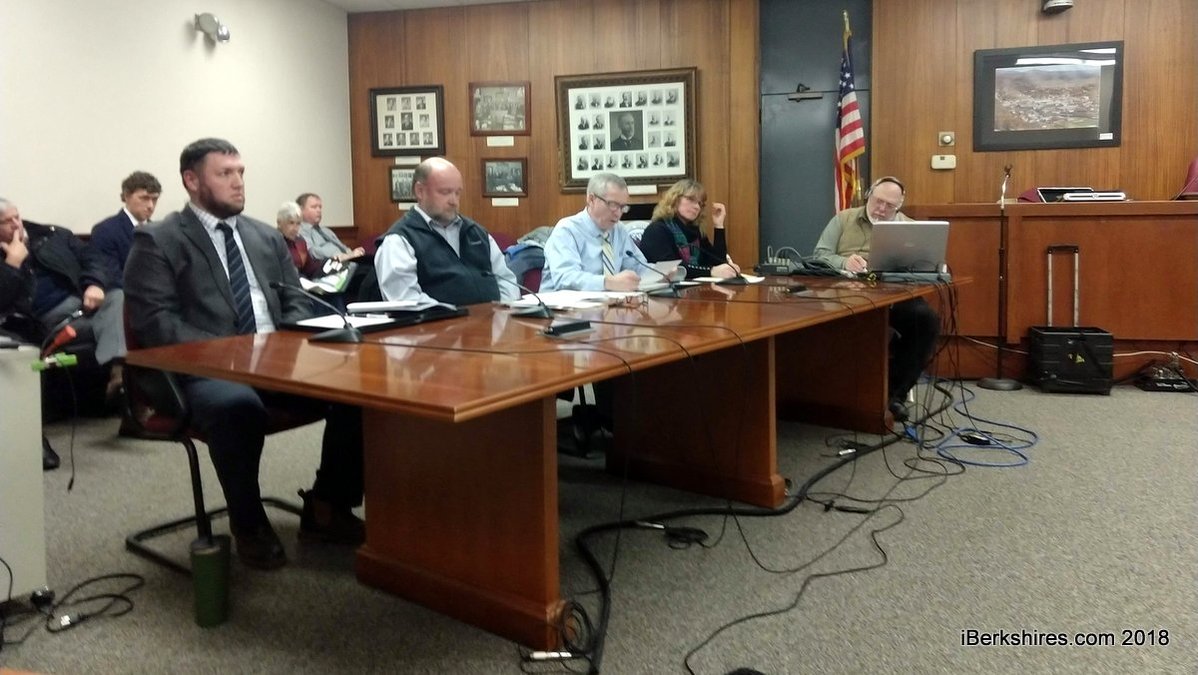
MassDOT engineers and designers answered questioned and updated residents on the project on Wednesday.
Resident Bret Beattie, however, saw the path as an opportunity for people, specifically youth, to interact with nature.
"When I think about wildlife and I think about youth and the need for youth to engage with nature not looking at it through a glass window but seeing a deer on the trail," he said. "Stopping dead in their tracks because they see some nature."
Another one of Bloxom's concerns was increased flooding on her property, which is bordered by a waterway.
Shedd said it is not in the scope of the project to alter the waterway, and it should not make any flooding worse.
One resident was concerned about bikers parking their vehicles in their neighborhoods to jump on the trail and Kearney said it would be up to the city if or how they wanted to enforce parking. He added that there would be designated parking along the trail.
There were also concerns about sidewalks and the signal. There were worries that with so many more pedestrians in the area using the signal traffic would back up.
In general, there was a safety concern about crossing the road but avid biker and user of the rail trail Barbara Lampron said drivers really "respect" the light in Cheshire where the trail crosses Route 8 and that it works well.
A general sentiment that resonated throughout the night was that the proposed path was a done deal.
"I see that this horseshoe red and I hear a lot of words and people are expressing their concerns and anything in favor of that red is acknowledged," Champney said. "Is it a done deal? Is it in cement? I feel like a sheep being herded the slaughterhouse."
City Councilor Jason LaForest had similar concerns and noted many of these same issues were brought up at previous meetings, but the path has not changed dramatically.
"I see you taking notes on things that already have been voiced for the second and third time, so I hope that will be addressed as you get to a higher percentage of your design phase," he said.
State Rep. John Barrett III said he thought it was getting late for a design change and that the designers and project managers are following the directive of the community.
"It should be understood that the whole concept of this latest one, and I don't mean to throw the mayor under the bus here, it comes from the town of Williamstown and the city of North Adams," he said. "It is based on what the local community wanted so when you ask if this is a done deal I don't know if it is, but these people are carrying out the directive they received from the local community."
He did say he thought a bike path was important to the area and while he was neither in favor nor in opposition to the selected path, he thought was important to protect the neighborhood.
There was support for the path in general and almost all of those who opposed it said they often used the rail trail or were avid bikers. The issue seemed to really be the location.
Others came out in full support including City Councilor Joshua Moran who felt the path was critical for development in the city and area.
"It will not only offer up the best views in the Hoosic River valley but will be the catalyst that will usher in a bike-pedestrian path that will connect Lanesborough to Williamstown," he said. "This is not an easy project, but I believe this design represents the best possible route."
Beattie agreed and feared that if the city did not go forward now, it would be left out.
"I know this will be a sacrifice for some in this room, but it is for the generations to come and great sacrifices have always been made by the current generations for the generations to come," he said. "We don't want to be left out and kick the can farther down the road and we have to start somewhere, or we will be left out of this opportunity."

 MEMBER SIGN IN